

In effect for Sonoma County: Coastal Flood Warning, Coastal Flood Advisory. Areas, timing and NWS instructions are below, as checked at 5:03 a.m. Pacific.
Santa Rosa right now
43°
Cloudy. Wind N 7 mph. Humidity 100%.
Reported 4:33 a.m. at Santa Rosa Sonoma County Airport, 7 miles from Santa Rosa.
Overnight: Areas of fog. Cloudy. Low around 40, with temperatures rising to around 42 overnight. North northeast wind around 1 mph.
Sunday: Patchy fog before noon. Mostly cloudy. High near 55, with temperatures falling to around 51 in the afternoon. North wind around 2 mph.
The next 24 hours
Santa Rosa
Santa Rosa, next 24 hours: high of 54 degrees around 2 p.m., low of 38 around 2 a.m. Chance of rain stays under 10%.
Bodega Bay
Bodega Bay, next 24 hours: high of 54 degrees around 2 p.m., low of 45 around 2 a.m. Chance of rain stays under 10%.
Tonight, town by town
The forecast high and low for each town. Tap a town for its full National Weather Service forecast.
- Santa Rosa
Low 40°Areas Of Fog
- Bodega Bay
Low 47°Cloudy
- Petaluma
- Sonoma
- Sebastopol
- Guerneville
- Healdsburg
- Cloverdale
Low 43°Mostly Cloudy
Around the county right now
Sonoma County. 43° to 48°. 43° near Santa Rosa (Santa Rosa Sonoma County Airport, 7 mi), cloudy, wind N 7 mph; 48° near Sonoma (Napa County Airport, 11 mi), cloudy, wind NNW 3 mph; 43° in Sebastopol, wind E 1 mph. Reported 4:26 a.m. to 4:39 a.m.
The week ahead
Santa Rosa NWS point forecast
- Overnight
- Sun
55° / 37° Patchy Fog then Mostly Cloudy
- Mon
- Tue
58° / 47°98% rainRain Likely then Showers And Thunderstorms
- Wed
61° / 46°56% rainLight Rain Likely
- Thanksgiving Day
64° / 47°25% rainChance Light Rain then Patchy Fog
- Fri
64° / 48°58% rainAreas Of Fog then Slight Chance Light Rain
Overnight: Areas of fog. Cloudy. Low around 40, with temperatures rising to around 42 overnight. North northeast wind around 1 mph. Sunday: Patchy fog before noon. Mostly cloudy. High near 55, with temperatures falling to around 51 in the afternoon. North wind around 2 mph.
Bodega Bay NWS point forecast
- Overnight
- Sun
55° / 44° Mostly Cloudy
- Mon
- Tue
60° / 54°99% rainRain then Showers And Thunderstorms
- Wed
- Thanksgiving Day
- Fri
62° / 54°63% rainMostly Cloudy then Slight Chance Light Rain
Overnight: Cloudy, with a low around 47. Northeast wind around 5 mph. Sunday: Mostly cloudy. High near 55, with temperatures falling to around 52 in the afternoon. North northeast wind 2 to 7 mph.
Radar and satellite

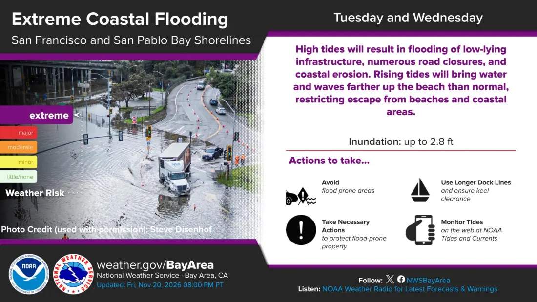
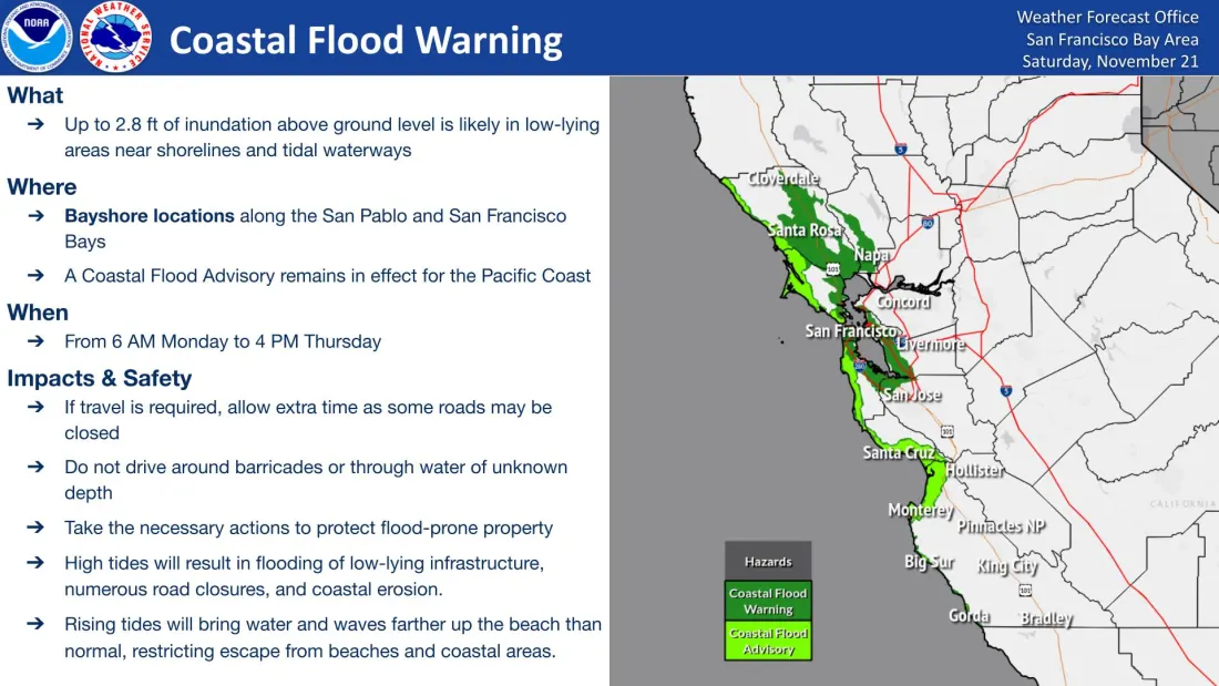
Regional graphics from the forecast office
The NWS San Francisco Bay Area forecast office, which forecasts for Sonoma County, posts these graphics. They cover the office’s whole area, not this county alone.
Watches, warnings and advisories
-
SevereCoastal Flood Warning
* WHAT…For the Coastal Flood Advisory, Up to 2.0 ft of inundation above ground level is possible in low-lying areas near shorelines and tidal waterways. For the Coastal Flood Warning, significant coastal flooding with up to 2.8 feet of inundation above ground level is possible in low-lying areas near shorelines and tidal waterways.
* WHERE…San Francisco and San Pablo Bay Shorelines.
* WHEN…For the Coastal Flood Advisory, until 6 AM PST Monday. For the Coastal Flood Warning, from 6 AM Monday to 4 PM PST Thursday.
* IMPACTS…High tides will result in flooding of low-lying infrastructure, numerous road closures, and coastal erosion. Rising tides will bring water and waves farther up the beach than normal, restricting escape from beaches and coastal areas.
* ADDITIONAL DETAILS…These predictions are approaching the highest tide ever recorded. At the San Francisco tide gauge, high tide is expected to be 2.0 ft above normal (7.8 ft MLLW) at 8:48 AM Sunday, 2.2 ft above normal (8.0 ft MLLW) at 9:25 AM Monday, 2.6 ft above normal (8.4 ft MLLW) at 10:05 AM Tuesday, 2.8 ft above normal (8.6 ft MLLW) at 10:49 AM Wednesday, and 2.4 ft above normal (8.2 ft MLLW) at 11:38 AM Thursday. These predictions include up to 1.6 ft of surge that will enhance the astronomical tide and flooding threat. High tide varies up to 90 minutes earlier or later along the Pacific Coast and through the San Francisco Bay, respectively.
NWS instructions: Take the necessary actions to protect flood-prone property. If travel is required, do not drive around barricades or through water of unknown depth.
-
* WHAT…Up to 2.8 ft of inundation above ground level is possible in low-lying areas near shorelines and tidal waterways.
* WHERE…Pacific Ocean Coast.
* WHEN…Through 4 PM PST Thursday.
* IMPACTS…High tides will result in flooding of low-lying infrastructure, isolated road closures, and coastal erosion. Rising tides will bring water and waves farther up the beach than normal, restricting escape from beaches and coastal areas.
* ADDITIONAL DETAILS…These predictions are approaching the highest tide ever recorded. At the San Francisco tide gauge, high tide is expected to be 2.0 ft above normal (7.8 ft MLLW) at 8:48 AM Sunday, 2.2 ft above normal (8.0 ft MLLW) at 9:25 AM Monday, 2.6 ft above normal (8.4 ft MLLW) at 10:05 AM Tuesday, 2.8 ft above normal (8.6 ft MLLW) at 10:49 AM Wednesday, and 2.4 ft above normal (8.2 ft MLLW) at 11:38 AM Thursday. These predictions include up to 1.6 ft of surge that will enhance the astronomical tide and flooding threat. High tide varies up to 90 minutes earlier or later along the Pacific Coast and through the San Francisco Bay, respectively.
NWS instructions: If travel is required, allow extra time as some roads may be closed. Do not drive around barricades or through water of unknown depth. Take the necessary actions to protect flood-prone property.
-
* WHAT…For the Coastal Flood Advisory, Up to 2.0 ft of inundation above ground level is possible in low-lying areas near shorelines and tidal waterways. For the Coastal Flood Warning, significant coastal flooding with up to 2.8 feet of inundation above ground level is possible in low-lying areas near shorelines and tidal waterways.
* WHERE…San Francisco and San Pablo Bay Shorelines.
* WHEN…For the Coastal Flood Advisory, until 6 AM PST Monday. For the Coastal Flood Warning, from 6 AM Monday to 4 PM PST Thursday.
* IMPACTS…High tides will result in flooding of low-lying infrastructure, numerous road closures, and coastal erosion. Rising tides will bring water and waves farther up the beach than normal, restricting escape from beaches and coastal areas.
* ADDITIONAL DETAILS…These predictions are approaching the highest tide ever recorded. At the San Francisco tide gauge, high tide is expected to be 2.0 ft above normal (7.8 ft MLLW) at 8:48 AM Sunday, 2.2 ft above normal (8.0 ft MLLW) at 9:25 AM Monday, 2.6 ft above normal (8.4 ft MLLW) at 10:05 AM Tuesday, 2.8 ft above normal (8.6 ft MLLW) at 10:49 AM Wednesday, and 2.4 ft above normal (8.2 ft MLLW) at 11:38 AM Thursday. These predictions include up to 1.6 ft of surge that will enhance the astronomical tide and flooding threat. High tide varies up to 90 minutes earlier or later along the Pacific Coast and through the San Francisco Bay, respectively.
NWS instructions: Take the necessary actions to protect flood-prone property. If travel is required, do not drive around barricades or through water of unknown depth.
Every figure on this page comes from the National Weather Service and is checked every 15 minutes; the graphics refresh hourly. Last change 5:03 a.m. Pacific, Nov. 22, 2026. No generative AI is used. All four counties, with sources.