

Updates
Update, 8:47 p.m. July 13: Cal Fire reports the Ledson Fire at 35% containment, with the fire held at 16.5 acres.
Update, 8:32 p.m. July 13: The Sonoma County Sheriff’s Office has downgraded the evacuation order for Zone SON-3H3 to an evacuation warning and lifted the order for Hood Mountain Regional Park. The zone takes in the homes around the park; those residents remain under a warning and have not been cleared to return. The alert reads: “Evacuation order for Hood Mountain Regional Park located in SON- 3H3 has been lifted.”
Update, 4:06 p.m. July 13: Cal Fire reports the Ledson Fire at 10% containment, with the fire held at 13.8 acres.
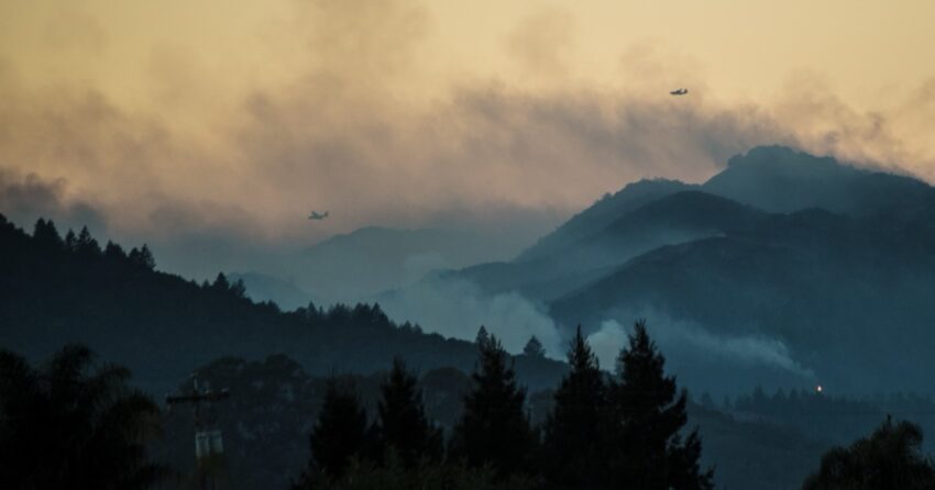
Cal Fire crews are fighting a 14-acre wildfire in the hills above Highway 12 east of Santa Rosa, and the Sonoma County Sheriff’s Office has ordered people out of the Hood Mountain area as the flames push east and uphill.
The Ledson Fire was dispatched at 1:01 p.m. Monday at Sonoma Highway and North Pythian Road, in the vineyard country at the foot of the Mayacamas. Cal Fire’s Sonoma-Lake-Napa Unit reported no containment as of 2:20 p.m. The cause is under investigation.
The fire grew steadily through its first hour. Cal Fire put it at 3 to 5 acres on the initial dispatch, 10 acres by 1:42 p.m., 13.8 acres by 2:02 p.m. and 14 acres by midafternoon.
Evacuation order covers Hood Mountain
The sheriff’s office issued an evacuation order at 2:16 p.m. for Zone SON-3H3, which takes in Hood Mountain Regional Park and the homes scattered around it.
The order covers the area north of Wildwood Trail and Wildwood Mountain Road, south of Timberline Drive, east of Los Alamos Road and west of the Napa County line and Hood Mountain Regional Park.
“If you are in this area, calmly and quickly evacuate now,” the sheriff’s office said in its alert. “First responders are going door to door to assist people.”
People who need help moving animals can call Sonoma CART at 707-861-0699. For livestock, the number is NorCal Livestock Evacuation at 707-234-7193. The county is directing questions to socoemergency.org or 2-1-1.
Anyone checking an address against the county map should look for SON-3H3. A different zone number, SON-3H1, circulated in early reports. Cal Fire and the sheriff’s office both identify the evacuated zone as SON-3H3.
A heavy assignment for a small fire
Cal Fire assigned six engines, four dozers, three air tankers, two Type 1 helicopters, an air attack plane, a helitack crew and two hand crews, with additional local government resources on scene.
That’s a lot of equipment for a fire still in the teens of acres. The terrain is why. Cal Fire described the fuels as light and flashy, oak woodland and brush, on a slope the fire is running straight up. Fires aligned with a slope preheat the vegetation above them and climb faster than crews can walk. The unit called for more air and ground resources inside the first hour.
The fire is also burning ground that has been through this twice in the past decade, and the geography lines up almost exactly. The 2017 Nuns Fire burned the southern end of Hood Mountain Regional Park, at the Pythian Road entrance — the same road the Ledson Fire started on. The 2020 Glass Fire burned the park’s northern side at the Los Alamos Road entrance, which forms the western edge of the zone the sheriff evacuated Monday. The Glass Fire alone burned about 80% of the 2,000-acre park, according to Sonoma County Regional Parks, and destroyed the Azalea Creek campground along with much of the trail system.
Cal Fire hasn’t reported any injuries or damaged structures. Its first dispatch said structures were threatened.
The official notices did not line up
Cal Fire’s incident page briefly muddied the picture Monday afternoon. Its log posted an evacuation order at 2:07 p.m., then two minutes later said the order had been lifted.
The sheriff’s office, which is the agency that orders evacuations in Sonoma County, issued its order at 2:16 p.m. — after that entry. The order stands.
Heat builds Tuesday
The National Weather Service in San Francisco issued a heat advisory at 10:49 a.m. Monday covering the North Bay interior mountains and valleys. It takes effect at 10 a.m. Tuesday and runs to 10 p.m., with highs in the 90s and hotspots reaching the low 100s.
Monday’s temperatures near the fire were in the low 90s. Crews still on the Ledson Fire Tuesday will be working it in hotter, drier air than they got on the first afternoon.
Cal Fire hasn’t reported a closure of Highway 12. The unit asked drivers near the fire to give way to emergency vehicles.
Frequently asked questions
How big is the Ledson Fire?
Cal Fire listed the fire at 14 acres as of its 2:20 p.m. update Monday, with no containment reported.
Which evacuation zone is under order?
Zone SON-3H3, covering Hood Mountain Regional Park and the surrounding area north of Wildwood Trail and Wildwood Mountain Road, south of Timberline Drive, east of Los Alamos Road and west of the Napa County line and Hood Mountain Regional Park.
Is Highway 12 closed?
Cal Fire hasn’t reported a closure. The unit asked drivers in the area to yield to emergency vehicles.
What started the Ledson Fire?
The cause is under investigation.
Where can I get help evacuating animals?
Sonoma CART at 707-861-0699 for household animals and NorCal Livestock Evacuation at 707-234-7193 for livestock.
Is a heat advisory in effect?
Not on Monday. The National Weather Service heat advisory for the North Bay interior mountains and valleys takes effect at 10 a.m. Tuesday and expires at 10 p.m. Tuesday.